Aerial and satellite imagery database
From 1967 to 1990, the Military Atmospheric Mapping Department of the Ministry of Defense of the Russian Federation, the Aero geodesy Plant in Moscow and Novosibirsk, and the State Geodesy and Cartography Agency were responsible for mapping the territory of Mongolia. Atmospheric imaging in Mongolia began in 1967, and satellite imagery in 1972.
During this period, the majority of maps taken from the atmosphere were mapped at a scale of 1:32,000, 1:45,000, 1:60,000, and 1: 100,000, and the majority of maps were taken from space satellites at 1: 200,000-1: 1,000. 000 scale maps.
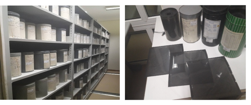
The following documents are stored in the aerial and satellite imagery database. These include:
- Aerial photographs taken in 1961-1983 and 1980-1994 - 354511 films;
- 2002 Aerial map of the border between the People's Republic of Mongolia and the People's Republic of China – 6000 хальс;
- Thematic (geology, soil, water, vegetation, etc.) maps – 2218 images;
- Satellite photographic plan at a scale of 1: 200 000-1: 1 000 000 and the source of its publication – 313 images;
- Large-scale topographic maps of urban areas – 222 pages;
- Orthophoto -3511 pages;
- Reproduction of aerial photography - 4014 items;
- Historical map of Mongolia - 272 pages;
- Aerial map of Ulaanbaatar and central settlements - 2252 films;
- Satellite images in electronic form - 1512 files.
Aerial maps are used for the following purposes. These include:
1. Geology and exploration of mineral deposits:
· 1: 17000, 1: 32000, 1: 45000, and 1: 60000 scale aerial maps are widely used to determine the distribution and detailed geological mapping of mineral deposits.
2. Forestry and its rehabilitation:
· 1: 17000, 1: 32000, and 1: 45000 scale aerial maps of forest distribution, resources, rehabilitation, and forest surveys.
3. Plant, soil, agriculture:
· 1: 17000 and 1: 32000 scale maps are used to determine crop status, distribution, humidity, soil erosion, its distribution, humidity, and crop area size.